By DENNIS WYATT
209 Living
DARDANELLE — As Sunday drives go, it’s tough to beat the 45 miles of Highway 108 that takes you from Sonora — the Queen of the Southern Mines — to lofty Sonora Pass at 9,624 feet.
Compared to the drive up its cousin trans-Sierra highway to the south — Highway 120 (Tioga Road) through Yosemite National Park — it’s virtually deserted. The real bonus is the scenery as you climb toward the pass from the highway rivals that along Tioga Road.
And unlike a Sunday drive to Tioga Pass at 9,945 feet through Yosemite you start in a teeming Gold Country community (Sonora) that is full of dining options, quaint shops, and even two professional live theatre groups.
You can depart Manteca and be at Sonora Pass — the state’s highest paved patch of highway asphalt after Tioga — in 2½ hours. Along the way after Sonora you will pass through a series of wide spots on the road — Mi-Wuk Village, Confidence, and Strawberry to name a few —that offer services and local gathering sports from general stories to restaurants.
There are numerous places turnoffs in and around the Highway 108 communities can lead you to including popular destinations such as Pinecrest Lake where you can fish, rent a boat, and enjoy other lake-orientated activities.
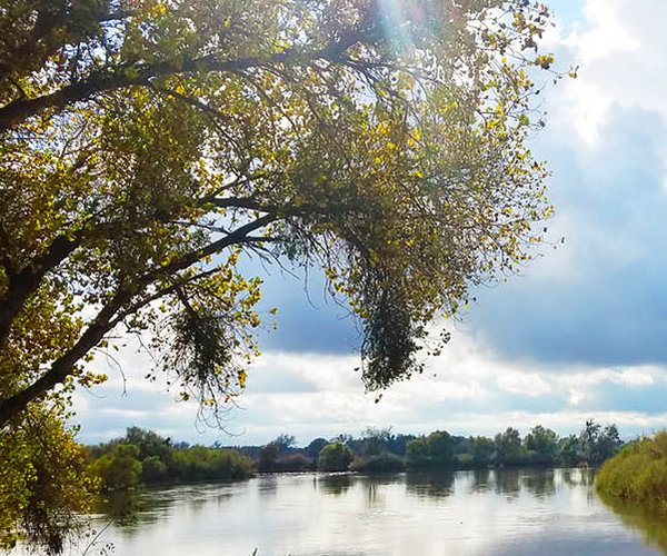
But Sonora Pass country doesn’t real start until you pass through Strawberry and Highway 108 takes you to the Donnell Overlook on the south side of the road. It’s a short 20 second walk — of that from your car to overlook. You get a view of Donnells Reservoir — the highest storage for the Tri-Dam Project that is a joint effort of the South San Joaquin Irrigation District and Oakdale Irrigation District to harness Stanislaus River runoff. The reservoir at 4,897 feet can store 56,893 acre feet of water. The steep granite walls shooting out of the water looks a tad like Hetch Hetchy in spots.
The Sonora Pass country that blends with the Stanislaus National Forest is arguably the most versatile high Sierra corridor when it comes to savoring Mother Nature’s offerings whether it is through camping and more passive pursuits such as photography, picnicking, gawking at scenery and bird watching today hiking, backpacking, bicycling, fishing, horseback riding, and even swimming.
There are 15 campgrounds you can access through the Stanislaus National Forest.
The last “civilization” before you start a compressed climb up Highway 108 to gain 3,500 feet —the pitch reaches 16 percent at one point — in less than 10 miles to Sonora Pass is the Dardanelle Resort that features a general store. Once you pass Dardanelle the Middle Fork of the Stanislaus River — the same river that flows past Oakdale, Ripon, and south of Manteca — pops up on your right. There are endless spots where you can pull over and walk just a matter of a dozen or so yards and be on the water’s edge.
There are granite outcroppings galore overlooking the water where you can fish, picnic, or simply sit and soak in the scenery. The middle fork runs along Highway 108 for a number of miles affording numerous opportunities to explore.
Just before Highway 108 leaves the 6,000 foot elevation for the stunning climb to Sonora Pass is the turn off for Kennedy Meadows.
Kennedy Meadows is a popular destination of fishermen, campers, hikers, horseback riders, backpackers and photographers. You will find Kennedy Meadows Resort, a pack station, and campgrounds along the banks of the Stanislaus River.
On a peacefulness level it cleans Tuloumne Meadows’ clock given it is off the beaten tourist destination track. It’ll take just one visit to understand why some families have bene returning to Kennedy Meadows for generations.
Beyond the Kennedy Meadows turnoff is my idea of nirvana, in terms of the western slope of the Sierra that I can access for a quick day trip to recharge.
People are sparse, traffic is light, the scenery, and the wilderness varied.
If you’re a bicyclist — particularly a roadie that likes racing bicycles — you won’t find a stretch of a trans-Sierra highway as friendly from the standpoint of attentive drivers or one that busts your quads as much.
That 16 percent pitch is for real. Just ask my quads. Granted it isn’t as bad as the 19 percent grade you’ve got to deal with if you opt to cross the pass and descend all the way to Highway 395 before heading back to your car.
The times I’ve tackled Sonora Pass for a day ride, I park at Cold Springs. It gives my body enough time to get warmed up thoroughly for the 3,500 feet you can to cover in less than 10 miles before reaching the pass. It also gets you acclimated and— if you are a mild mileage junkie — you get enough miles in that you don’t feel as if you’re cheating yourself.
Just a mile or so before the pass, Highway 108 levels out somewhat — at least compared to the steep climbs to get there. This is where you will find a small meadow with a stream running through it.
The first time I saw it in mid-summer, I was captivated. But when I saw it in the twilight between mid and late fall for the first time, I was in love. The visual palette of fall colors with aspen, sugar pines and other trees against a canvas of granite makes it my absolutely favorite spot in the Sierra that you can literally drive right up to on a highway. No other place comes close.
How much do I like it? After spending months one time agonizing over a catalogue unique watercolor prints Ripon artist Don Peterson had of various Sierra spots — I was interested primarily in Yosmeite — and having reservations about doling out $500, I stopped by his home studio to finally make my purchase.
Peterson pulled out a reproduction print, and unrolled it. It wasn’t the one I asked for. But before he could even say “that’s not it” I told him I’d take it.
The watercolor print captured the deep blues, grays, and purples of granite caught in the shadow as the sun starts rising behind the amount and the bursts of golds and greens in the meadow illuminated by the early rays was just like the first time I saw the spot near Sonora Pass in person on an October morning years before. It is the only art per se hanging on my walls. The spot — which you don’t even have to get out of your car to savor — is that incredible.
It wasn’t until recent years that I discovered what hikes and backpackers that cross through the Sonora Pass country already knew — it is ground zero for wildflowers in the Sierra.
The late and heavy snows meant I was able to cross thousands upon thousands hiking last Saturday to Sonora Peak at 11,459 feet.
The 6.2-mile hike to Sonora Peak has a 2,152-foot gain and is rated as difficult. To be honest, that may be a little hyped. While there is loose scree in a steep part as you start your final ascent, it is manageable for most people. A large group out of Sonora that included some novice older hikes not in top shape were able to summit by simply tackling it at their pace.
But you don’t have to be a hardcore hiker or a borderline goat to enjoy wildflowers and impressive views. The St, Mary’s Trailhead — it is unmarked on your left a short ways west of the pass but you can see the dirt parking area if you keep an eye out —has some rewarding views within a half mile of the parking lot. Wildflowers — and patched of snow — started popping up there last Saturday. It starts climbing a bit after that. The farther you go, the more you are rewarded with things like small streams, large snow patches, and more wildflowers.
If you simply go to St. Mary’s Pass, you will be rewarded 10-fold. It can be a climb to get to that point but it’s not as bad as if you went on toward Sonora Peak.
At any rate, once you crest St. Mary’s Pass, you will be greeted by a stunning vista of mountain peaks. There is still a significant amount of snow on the ground in spots — the area to the west had snow in mid-August last year when we were still in a drought. If you want to try Sonora Peak. It is the trail that starts heading east just after you crest the pass.
The other options for a day hike or simple a causal jaunt, is at the pass itself. There is a paved parking area with pit toilets just before the pass on the north side of Highway 108.
Most of the time if there is space available I’ll park by the sign marking the summit. This is where the Pacific Crest Trail crosses Highway. South of the highway takes you to a stress that many who have done the trail from Mexico to Canada claims is the most impressive vista. It’s been dubbed the 100-mile view. I’d say it requires more hiking/elevation gain before seeing any spectacular views or wildflowers than if you head north on the PCT from the highway.
If you’re new to hiking, it won’t kill you. Your best option for views and wildflowers in the shortest distance in the event you decided you’ve reached your turn aroiund point is the trail to St. Mary’s Pass.
You can’t go wrong if all you want to do is to up to Sonora Pass country for a Sunday drive.
If you do that, you will want to make a return trip in late October or early November. Seeing the Sonora Pass country under the majestic cloak of both seasons will stick with you for a lifetime.
To contact Dennis Wyatt, email dwyatt@mantecabulletin.com